Handlekurven er tom
Handlekurven er tom
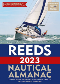
Reeds Nautical Almanac is the indispensable trusted annual compendium of navigational data for yachtsmen and motorboaters, and provides all the information required to navigate Atlantic coastal waters around the whole of the UK, Ireland, Channel Islands and the entire European coastline from the tip of Denmark right down to Gibraltar, Northern Morocco, the Azores and Madeira.
The 2022 edition continues the Almanac's tradition of year on year improvement and meticulous presentation of all the data required for safe navigation. Now with an improved layout for easier reference and with over 45,000 annual changes, it is regarded as the bible of almanacs for anyone going to sea.
The 2022 edition is updated throughout, containing over 45,000 changes, and includes: 700 harbour chartlets; tide tables and tidal streams; buoyage and lights; 7,500 waypoints; invaluable passage notes; distance tables; radio, weather and safety information; first aid section. Also: a free Marina Guide.
The print version includes: 700 chartlets, Harbour facilities, Tide tables and streams, 7,500 waypoints, International codes and flags, Weather, Distance tables, Passage advice, Area planning charts, Rules of the road, Radio information, Communications, Safety, Mayday and distress procedures, and Documentation and Customs.

World Cruising Routes is a comprehensive guide to nearly 1000 sailing routes covering all the oceans of the world, from the tropical South...

This book provides rapidly accessible guidelines for dealing with medical emergencies in a small boat or yacht at sea. It is not a...

If you own a small marine diesel engine that you depend on--at least occasionally--this book was written for you. Nigel Calder, a diesel...

The Atlantic Crossing Guide is well established as the standard reference for anyone planning an Atlantic voyage, whether via the trade wind...

Overseilingskart for Atlanterhavet nordlige del. Dette er et storsirkelkart fra Imray. Noen anbefalte ruter, samt distanser er tegnet inn...

This second edition has been extensively revised to bring it up to date with changes to formalities and facilities around the world in the past few...