Handlekurven er tom
Handlekurven er tom

|
CD of Charts - Navigation Software |
|
|
Digital Photos of Anchorages |
|
|
Includes Harbour & Anchorage Charts |
|
|
|
|
|
GPS Charted Waypoints & Approaches |
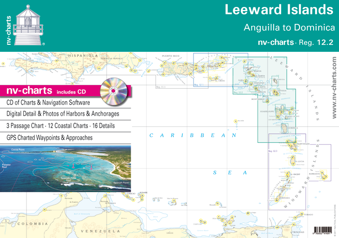
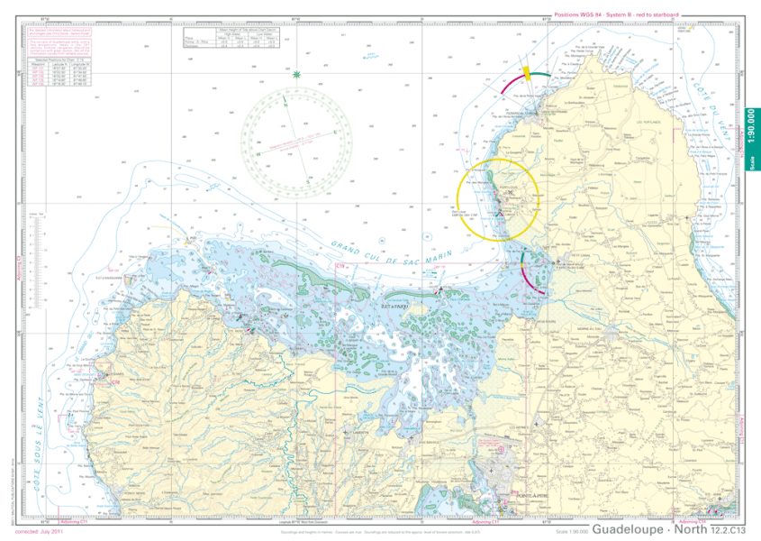
The NV. Charts are characterised by fine contours and easy to distinguish colour graduations of the depth lines - turquoise for coral reefs, red for the 2-meter-line and blue for the 5-m-areas. Presented in a handy, user friendly size, (23½"" x 16 ½"") a thick plastic envelope protects the charts, enabling them to be easily stored.The importance of good graphical representation of the topography when sailing in the Caribbean is essential. Well marked rivers, towns and street plans all help to give a clear overall view of the shoreside facilities of the islands.
Red numbered waypoints with coordinates based on WGS 84 enable yachtsmen to navigate using their GPS instruments. Heights and depths are given in the internationally accepted format of meters. Large scale approaches and land contour markings simplify the entrance into anchorages.'The NV.Charts are coordinated with Chris Doyles" well known Sailors Guides with the use of cross referenced numbered harbours and anchorages.
NV Charts er et tysk kartforlag som har laget kart i over 30 år. De har utgitt kart over Tyskland, Danmark og Karibien i mange år. De siste årene har områdene blitt utvidet til også å gjelde deler av Sverige, Norge og USA.
Forlaget satser på kombipakker hvor man kjøpe papirkart og elektroniske sjøkart i en pakke. De elektroniske kartene kan brukes både på nettbrett, smarttelefon og PC.

Vare nr. PI3051
A Cruising Guide to the Leeward Islands is the completely updated 2nd edition of Stephen Pavlidis's comprehensive guide. Now in full colour, with...

Vare nr. PI3042
This popular book covering the Caribbean from Grenada and Barbados to the Virgin Islands is a translation from Jacques Patuelli's original French...


Nav Update er en oppdateringsbrikke hvor du gjør oppdateringen selv. Du kan med denne oppdatere ditt gamle Navionics sjøkart til Nav+,...


This map of the inland waterways of Scotland provides medium scale coverage of the Caledonian Canal, Forth and Clyde Canal and Crinan...

Kintyre to Ardnamurchan is the last of the CCC's four west coast volumes to be merged with Martin Lawrence's Yachtsman's Pilots which, in this...